Wednesday, March 9, 2011

Rains from Tropical Cyclone Carlos

Tropical Cyclone Carlos brought heavy rains to the coasts of Northern Territory and Western Australia in February 2011. In the Northern Territory city of Darwin, Carlos helped break rainfall records in what was already an unusually rainy month. The storm’s high winds and heavy rains also forced the suspension of petroleum and mining projects in Western Australia, according to news reports.


Rains from Tropical Cyclone Carlos


Tropical Cyclone Carlos


The U.S. Navy’s Joint Typhoon Warning Center (JTWC) reported that, as of 11:00 p.m. Western Australia time on February 22, Carlos was located roughly 100 nautical miles (185 kilometers) east-northeast of Learmonth, Western Australia. The storm had maximum sustained winds of 55 knots (100 kilometers per hour) and gusts up to 70 knots (130 kilometers per hour). Carlos was forecast to maintain its current strength over the next 12 hours then move west of Learmonth and intensify slightly. The storm was not expected to transition to an extra-tropical storm for about 96 hours.


http://earthobservatory.nasa.gov/NaturalHazards/view.php?id=49404&src=nha

4.7 Magnitude Earthquake Near Guy, Arkansas

The small seismic zone that has been producing an earthquake swarm near Guy and Greenbrier, Arkansas has now produced a 4.7 magnitude earthquake – the strongest so far. The earthquake occurred on Sunday, February 27 at about 11:00 PM local time and at a depth of about 3 kilometers. 


http://earthquake.usgs.gov/earthquakes/recenteqsus/Quakes/nm022811a.php

NZ quake sends 30 million tons of ice loose from glacier

The 6.3 magnitude earthquake that struck New Zealand on Tuesday, killing at least 75 people in Christchurch, also shook loose 30 million tons of ice from the nation's longest glacier, sending boulders of ice into a nearby lakeTourists on a boat watch an iceberg, broken off from the glacier after Tuesday's earthquake, in the Tasman Lake, 200km (124 miles) southeast of Christchurch in this handout photograph released February 23, 2011. The 6.3 magnitude earthquake that struck New Zealand on Tuesday, killing at least 75 people in Christchurch, also shook loose 30 million tonnes of ice from the nation's longest glacier, sending boulders of ice into a nearby lake. REUTERS/Denis Callesen/Handout
Tour boat operators in the area said parts of the Tasman Glacier calved into the Tasman Lake immediately after the quake, breaking into smaller icebergs and causing 3.5 meter-high (11-foot) waves.
"It was approximately 30 million tons of ice, it's just a massive, massive, massive scale," said Denis Callesen, the General Manager of Tourism at Aoraki Mount Cook Alpine Village.


Twisters kill three in Minnesota


Deadly tornadoes touched down Thursday in Minnesota, killing at least three people, and injuring at least 17 more, officials said.Minnesota suffered widespread damage and power outages, said Doug Neville, a spokesman for the state's public safety department. He said Gov. Tim Pawlenty was on his way to survey the damage in affected areas.


The twisters hit the town of Wadena hard, ripping off roofs and damaging schools, buses and stores. Neville said 14 people had been taken to hospitals, 13 of them in critical condition.


http://www.cnn.com/2010/US/06/18/minnesota.tornado.deaths/index.html?hpt=Sbin

Discovering Giant Seamounts in the South Atlantic Ocean

In the latest evidence of the vastness remaining to be explored in the world's oceans, scientists aboard Scripps Institution of Oceanography at UC San Diego's research vessel Melville are mapping a series of colossal and previously uncharted undersea mountains in remote areas of the South Atlantic Ocean
 South Atlantic Seamounts

With the largest seamount rising more than 14,700 feet from the seafloor —- higher than California's Mount Whitney, the tallest mountain in the contiguous United States -— the mountains had been known from satellite data but never before charted at sea. 


http://geology.com/press-release/south-atlantic-seamounts/

Mount Etna - Italy

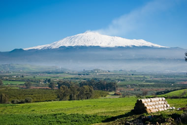
Mount Etna is Europe’s highest and most active volcano. Towering above the city of Catania on the island of Sicily, it has been growing for about 500,000 years and is in the midst of a series of eruptions that began in 2001. It has experienced a variety of eruption styles, including violent explosions and voluminous lava flows. More than 25% of Sicily’s population lives on Etna’s slopes, and it is the main source of income for the island, both from agriculture (due to its rich volcanic soil) and tourism. 
Mount Etna with snowcap

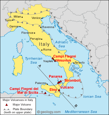
Mount Etna is associated with the subduction of the African plate under the Eurasian plate, which also produced Vesuvius and Campi Flegrei, but is part of a different volcanic arc (the Calabrian rather than Campanian)
location map for Vesuvius volcano


http://geology.com/volcanoes/etna/

SCIENTISTS FIND INCREASE IN MICROEARTHQUAKES AFTER CHILEAN QUAKE

By studying seismographs from the earthquake that hit Chile last February, earth scientists at the Georgia Institute of Technology have found a statistically significant increase of microearthquakes in central California in the first few hours after the main shock. The observation provides an additional support that seismic waves from distant earthquakes could also trigger seismic events on the other side of the earth. The results may be found online in the journalGeophysical Research Letters.

It has been well known that microearthquakes can be triggered instantaneously by distant earthquakes. However, sometimes the triggered events could occur long after the passage of the direct surface waves that take the shortest path on the earth surface. There are several other explanations out there about how such delayed triggering occurs. Some involve the redistribution of pore fluids and triggered aseismic creep, while others simply consider them as aftershocks of the directly triggered events. But the group from Georgia Tech found something different.


http://www.gatech.edu/newsroom/release.html?nid=64623

Earthquake Survey for the Eastern Tennessee Seismic Zone

A new research project at the University of Tennessee, Knoxville will provide the first-ever record of seismic activity in the Tennessee Valley, providing new information not only on past quakes but insight into future activity, as well. 

Led by Robert Hatcher, UT Knoxville distinguished scientist and professor of earth and planetary sciences, the research team will explore sites from just north of Knoxville, Tenn., through the Chattanooga area to just north of Rome, Ga. 
Tennessee seismic zone map

The area, known as the East Tennessee Seismic Zone (ETSZ), is the second most active area for earthquake activity in the eastern U.S. The Nuclear Regulatory Commission is funding the study.

http://geology.com/press-release/eastern-tennessee-seismic-zone/