Monday, April 25, 2011

Hawaiian Volcano Crater Floor Collapse Followed by Eruption in Fissue Along Kilauea's East Rift Zone

A fissure that opened on Kilauea's east rift zone after the March 5 collapse of the Pu'u 'O'o crater floor continues to erupt lava. Activity along the fissure was sporadic overnight and throughout March 6, with periods of quiet punctuated by episodes of lava spattering up to 25 m (80 ft) high.

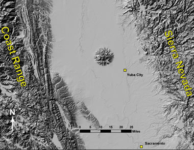
The fissure is located west-southwest of Pu'u 'O'o in a remote area of Hawai'i Volcanoes National Park. Due to the ongoing volcanic activity, Park closures remain in effect in this area.

http://www.sciencedaily.com/releases/2011/03/110306234145.htm

Where Will the Debris from Japan's Tsunami Drift in the Ocean?

The huge tsunami triggered by the 9.0 Tohoku Earthquake destroyed coastal towns near Sendai in Japan, washing such things as houses and cars into the ocean. Projections of where this debris might head have been made by Nikolai Maximenko and Jan Hafner at the International Pacific Research Center, University of Hawaii at Manoa. Maximenko has developed a model based on the behavior of drifting buoys deployed over years in the ocean for scientific purposes.

Maximenko's long-standing work on ocean currents and transports predicted that there are five major regions in the World Ocean where debris collects if it is not washed up on shores or sinks to the ocean bottom, deteriorates, or is ingested by marine organisms. These regions turn out to be "garbage patches." The North Pacific Garbage Patch has become famous, the North Atlantic Patch was fixed some years ago, and the South Atlantic, South Indian Ocean, and South Pacific patches have just been found, guided by the map of his model that shows where floating marine debris should collect.

http://www.sciencedaily.com/releases/2011/04/110406102203.htm

landslide risk sends 9 families from homes

Nine families in Saint-Jude, Que., will have to wait several months to return to their homes after a riverbank collapsed on Wednesday.
The homes are in the same area, an hour's drive northeast of Montreal, where a family of four died last year after their home was swallowed by mud in a massive landslide.
On Sunday, a large section of one of the banks of the Salvail River eroded and collapsed into the water.
Saint-Jude Mayor Yves de Bellefeuille said town and provincial officials decided to evacuate the nine homes nearby as a precaution.
"Last year's loss of an entire family was not easy and we told ourselves that we did not want to lose any others. We aren't taking any chances," said Bellefeuille, mayor of the town of 1,000.


http://www.cbc.ca/news/canada/montreal/story/2011/04/21/saint-jude-homes-evacuated-landslide-risk.html

Strong earthquake rocks Indonesia’s Sulawesi, causes damage

KENDARI, INDONESIA
A strong earthquake struck the Indonesian island of Sulawesi on early Monday morning, seismologists said, causing some damage but no casualties.
The 6.0-magnitude earthquake at 7.07 a.m. local time (2307 GMT Sunday) was centered about 75 kilometers (46 miles) south-southeast of Kendari, the capital of South East Sulawesi province. It struck about 18 kilometers (11 miles) deep, making it a shallow earthquake, according to Indonesia's Meteorological, Climatology and Geophysics Agency (BMKG).

Most recently, on October 25, 2010, a powerful 7.7-magnitude earthquake struck just off the Mentawai Islands off the western coast of Sumatra. As a result, a wall of water killed at least 435 people on the islands and impacted more than 20 villages.


http://channel6newsonline.com/2011/04/strong-earthquake-rocks-indonesias-sulawesi-causes-damage/

Sunday, April 24, 2011

Earth Recovered from Prehistoric Global Warming Faster Than Previously Thought

When faced with high levels of atmospheric carbon dioxide and rising temperatures 56 million years ago, Earth increased its ability to pull carbon from the air. This led to a recovery that was quicker than anticipated by many models of the carbon cycle -- though still on the order of tens of thousands of years, said Gabriel Bowen, the associate professor of earth and atmospheric sciences who led the study.


"We found that more than half of the added carbon dioxide was pulled from the atmosphere within 30,000 to 40,000 years, which is one-third of the time span previously thought," said Bowen, who also is a member of the Purdue Climate Change Research Center. "We still don't know exactly where this carbon went, but the evidence suggests it was a much more dynamic response than traditional models represent."

http://www.sciencedaily.com/releases/2011/04/110421151919.htm

World's Biggest Tsunami

On the night of July 9, 1958 an earthquake along the Fairweather Fault in the Alaska Panhandle loosened about 40 million cubic yards (30.6 million cubic meters) of rock high above the northeastern shore of Lituya Bay. This mass of rock plunged from an altitude of approximately 3000 feet (914 meters) down into the waters of Gilbert Inlet (see map below). The impact generated a local tsunami that crashed against the southwest shoreline of Gilbert Inlet. The wave hit with such power that it swept completely over the spur of land that separates Gilbert Inlet from the main body of Lituya Bay. The wave then contiuned down the entire length of Lituya Bay, over La Chaussee Spit and into the Gulf of Alaska. The force of the wave removed all trees and vegetation from elevations as high as 1720 feet (524 meters) above sea level. Millions of trees were uprooted and swept away by the wave. This is the highest wave that has ever been known.

Sutter Buttes—The Lone Volcano in California’s Great Valley

The volcanic spires of the Sutter Buttes tower 2,000 feet above the farms and fields of California’s Great Valley, just 50 miles northnorthwest of Sacramento and 11 miles northwest of Yuba City. The only volcano within the valley, the Buttes consist of a central core of volcanic domes surrounded by a large apron of fragmental volcanic debris. Eruptions at the Sutter Buttes occurred in early Pleistocene time, 1.6 to 1.4 million years ago. The Sutter Buttes are not part of the Cascade Range of volcanoes to the north, but instead are related to the volcanoes in the Coast Ranges to the west in the vicinity of Clear Lake, Napa Valley, and Sonoma Valley.

The Sutter Buttes stand as a remarkable geographic and geologic feature of California’s Great Valley, and they remain a subject of scientific interest and research. One curious feature is the presence at the surface in the castellated core of a huge block, one-quarter mile across, of crystalline rock (Cretaceous granite) characteristic of the Sierran basement. This is one of many puzzles remaining for geologists to solve in future studies.

http://geology.com/usgs/sutter-buttes/

Tsunami Waves Hit Hawaii Islands After Devastating Japan Coast

Hawaii was hit by a 1-meter (39-inch) wave, according to scientists at the Pacific Tsunami Warning Center, which wasn’t anticipating major damage.

The tsunami swept through Hawaii about seven hours after Japan was struck by its strongest earthquake on record. The 8.9- magnitude temblor shook buildings across Tokyo and unleashed a seven-meter-high tsunami that killed hundreds as it engulfed towns on the northern coast. Within hours of reaching Hawaii, waves were hitting the coast of Oregon, the Associated Press reported.


http://www.bloomberg.com/news/2011-03-11/hawaii-hit-by-1-meter-tsunami-spurring-coastal-evacuations-closing-ports.html

Earthquake Sound of the Mw9.0 Tohoku, Japan earthquake (Zhigang Peng)

The Japan earthquake was recorded by two of the world's densest strong motion seismic networks, namely the K-Net and the Kik-Net. The example showing here was recorded by the K-Net station MYG004, which has the highest peak ground acceleration (PGA) of up to 3 g. This near-field recording show clearly two groups of ground motion, suggesting at least two patches of high-frequency radiation from the mainshock rupture. The highest PGA occurred at around 90 s, and the frequency and sound is quite different than the rest group, indicating that the source of such high-frequency radiation is likely very close to this station.

http://geophysics.eas.gatech.edu/people/zpeng/Japan_20110311/index.html

Wednesday, March 9, 2011

Rains from Tropical Cyclone Carlos

Tropical Cyclone Carlos brought heavy rains to the coasts of Northern Territory and Western Australia in February 2011. In the Northern Territory city of Darwin, Carlos helped break rainfall records in what was already an unusually rainy month. The storm’s high winds and heavy rains also forced the suspension of petroleum and mining projects in Western Australia, according to news reports.


Rains from Tropical Cyclone Carlos


Tropical Cyclone Carlos


The U.S. Navy’s Joint Typhoon Warning Center (JTWC) reported that, as of 11:00 p.m. Western Australia time on February 22, Carlos was located roughly 100 nautical miles (185 kilometers) east-northeast of Learmonth, Western Australia. The storm had maximum sustained winds of 55 knots (100 kilometers per hour) and gusts up to 70 knots (130 kilometers per hour). Carlos was forecast to maintain its current strength over the next 12 hours then move west of Learmonth and intensify slightly. The storm was not expected to transition to an extra-tropical storm for about 96 hours.


http://earthobservatory.nasa.gov/NaturalHazards/view.php?id=49404&src=nha

4.7 Magnitude Earthquake Near Guy, Arkansas

The small seismic zone that has been producing an earthquake swarm near Guy and Greenbrier, Arkansas has now produced a 4.7 magnitude earthquake – the strongest so far. The earthquake occurred on Sunday, February 27 at about 11:00 PM local time and at a depth of about 3 kilometers. 


http://earthquake.usgs.gov/earthquakes/recenteqsus/Quakes/nm022811a.php

NZ quake sends 30 million tons of ice loose from glacier

The 6.3 magnitude earthquake that struck New Zealand on Tuesday, killing at least 75 people in Christchurch, also shook loose 30 million tons of ice from the nation's longest glacier, sending boulders of ice into a nearby lakeTourists on a boat watch an iceberg, broken off from the glacier after Tuesday's earthquake, in the Tasman Lake, 200km (124 miles) southeast of Christchurch in this handout photograph released February 23, 2011. The 6.3 magnitude earthquake that struck New Zealand on Tuesday, killing at least 75 people in Christchurch, also shook loose 30 million tonnes of ice from the nation's longest glacier, sending boulders of ice into a nearby lake. REUTERS/Denis Callesen/Handout
Tour boat operators in the area said parts of the Tasman Glacier calved into the Tasman Lake immediately after the quake, breaking into smaller icebergs and causing 3.5 meter-high (11-foot) waves.
"It was approximately 30 million tons of ice, it's just a massive, massive, massive scale," said Denis Callesen, the General Manager of Tourism at Aoraki Mount Cook Alpine Village.


Twisters kill three in Minnesota


Deadly tornadoes touched down Thursday in Minnesota, killing at least three people, and injuring at least 17 more, officials said.Minnesota suffered widespread damage and power outages, said Doug Neville, a spokesman for the state's public safety department. He said Gov. Tim Pawlenty was on his way to survey the damage in affected areas.


The twisters hit the town of Wadena hard, ripping off roofs and damaging schools, buses and stores. Neville said 14 people had been taken to hospitals, 13 of them in critical condition.


http://www.cnn.com/2010/US/06/18/minnesota.tornado.deaths/index.html?hpt=Sbin

Discovering Giant Seamounts in the South Atlantic Ocean

In the latest evidence of the vastness remaining to be explored in the world's oceans, scientists aboard Scripps Institution of Oceanography at UC San Diego's research vessel Melville are mapping a series of colossal and previously uncharted undersea mountains in remote areas of the South Atlantic Ocean
 South Atlantic Seamounts

With the largest seamount rising more than 14,700 feet from the seafloor —- higher than California's Mount Whitney, the tallest mountain in the contiguous United States -— the mountains had been known from satellite data but never before charted at sea. 


http://geology.com/press-release/south-atlantic-seamounts/

Mount Etna - Italy

Mount Etna is Europe’s highest and most active volcano. Towering above the city of Catania on the island of Sicily, it has been growing for about 500,000 years and is in the midst of a series of eruptions that began in 2001. It has experienced a variety of eruption styles, including violent explosions and voluminous lava flows. More than 25% of Sicily’s population lives on Etna’s slopes, and it is the main source of income for the island, both from agriculture (due to its rich volcanic soil) and tourism. 
Mount Etna with snowcap

Mount Etna is associated with the subduction of the African plate under the Eurasian plate, which also produced Vesuvius and Campi Flegrei, but is part of a different volcanic arc (the Calabrian rather than Campanian)
location map for Vesuvius volcano


http://geology.com/volcanoes/etna/

SCIENTISTS FIND INCREASE IN MICROEARTHQUAKES AFTER CHILEAN QUAKE

By studying seismographs from the earthquake that hit Chile last February, earth scientists at the Georgia Institute of Technology have found a statistically significant increase of microearthquakes in central California in the first few hours after the main shock. The observation provides an additional support that seismic waves from distant earthquakes could also trigger seismic events on the other side of the earth. The results may be found online in the journalGeophysical Research Letters.

It has been well known that microearthquakes can be triggered instantaneously by distant earthquakes. However, sometimes the triggered events could occur long after the passage of the direct surface waves that take the shortest path on the earth surface. There are several other explanations out there about how such delayed triggering occurs. Some involve the redistribution of pore fluids and triggered aseismic creep, while others simply consider them as aftershocks of the directly triggered events. But the group from Georgia Tech found something different.


http://www.gatech.edu/newsroom/release.html?nid=64623

Earthquake Survey for the Eastern Tennessee Seismic Zone

A new research project at the University of Tennessee, Knoxville will provide the first-ever record of seismic activity in the Tennessee Valley, providing new information not only on past quakes but insight into future activity, as well. 

Led by Robert Hatcher, UT Knoxville distinguished scientist and professor of earth and planetary sciences, the research team will explore sites from just north of Knoxville, Tenn., through the Chattanooga area to just north of Rome, Ga. 
Tennessee seismic zone map

The area, known as the East Tennessee Seismic Zone (ETSZ), is the second most active area for earthquake activity in the eastern U.S. The Nuclear Regulatory Commission is funding the study.

http://geology.com/press-release/eastern-tennessee-seismic-zone/

Saturday, February 12, 2011

Lockyer Valley hammered by "inland tsunami"

The Lockyer Valley has been decimated after an eight metre "inland tsunami" swept through Toowoomba and then down the range on Monday and Tuesday.

The Lockyer Creek reached a record peak of 18.93m at Gatton on Monday night before the gauge failed, but waters continued to rise on Tuesday as the creek caused a wave of destruction through the region. Many roads have been destroyed.


The Lockyer Creek at Laidley.


http://qcl.farmonline.com.au/news/state/agribusiness-and-general/general/lockyer-valley-hammered-by-inland-tsunami/2046541.aspx

M7.0 Earthquake Near Concepcion, Chile

A magnitude 7.0 earthquake occurred near Concepcion, Chile on Friday, February 11 at about 5:05 PM local time. The USGS instrumental intensity map shows values of VI to VII near the epicenter.


http://geology.com/news/2011/m7-0-earthquake-near-concepcion-chile.shtml

The San Andreas Fault

The San Andreas Fault is the sliding boundary between the Pacific Plate and the North American Plate. It slices California in two from Cape Mendocino to the Mexican border.

The San Andreas Fault is a transform fault. Imagine placing two slices of pizza on the table and sliding them past one another where they touch along a common straight edge.
The plates are slowly moving past one another at a couple of inches a year - about the same rate that your fingernails grow. But this is not a steady motion, it is the average motion.

http://geology.com/articles/san-andreas-fault.shtml

Mount Vesuvius - Italy

Vesuvius is part of the Campanian volcanic arc, a line of volcanoes that formed over a subduction zone created by the convergence of the African and Eurasian plates

Vesuvius is the only active volcano in mainland Europe. It has produced some of the continent’s largest volcanic eruptions. Located on Italy’s west coast, it overlooks the Bay and City of Naples and sits in the crater of the ancient Somma volcano. Vesuvius is most famous for the 79 AD eruption which destroyed the Roman cities of Pompeii and Herculaneum. Though the volcano’s last eruption was in 1944, it still represents a great danger to the cities that surround it, especially the busy metropolis of Naples.

Tuesday, February 1, 2011

Massive Earthquake Hits Southwest Pakistan

PAKQUAKEmap

ISLAMABAD, Pakistan—A 7.2-magnitude earthquake jolted southwestern Pakistan early on Wednesday in a sparsely-populated area near the nation's borders with Iran and Afghanistan, according to the U.S. Geological Survey.

The quake's aftershocks were felt in New Delhi, India's capital, more than 700 miles away, with walls shaking for a few seconds.

An earthquake of similar intensity in Pakistan's Kashmir region killed more than 70,000 people in 2005. The area hit by the quake on Wednesday is known for its seismic activity. The country is also still reeling from last summer's deadly flooding, which killed almost 2,000 people, affected 20 million others, and caused billions of dollars in damages.

Still, there remains opportunity in natural disasters. The U.S. response to the Pakistan earthquake in 2005, which killed more than 70,000, was widely praised. The defense department flew thousands of helicopter sorties and the State Department funneled in hundreds of millions in relief aid. The quick response was credited with raising public opinion of America throughout Pakistan, at least temporarily.

http://online.wsj.com/article/SB10001424052748703954004576090331100675282.html

Haiti Dominates Earthquake Fatalities in 2010

In 2010, about 227,000 people were killed due to earthquakes, with over 222,570 from the magnitude-7.0 Haiti event, as reported by the United Nations Office for Coordination of Humanitarian Affairs.
 

In 2010, 22 earthquakes reached a magnitude of 7.0 or higher, including the Chile quake that exceeded magnitude 8.0. These numbers are higher than those of 2009, which experienced 17 earthquakes over magnitude 7.0, including one over 8.0. While 22 earthquakes of magnitude 7.0 or greater is more than the average per year, and is the largest number of big events since 1968, it is still substantially fewer than 1943, which experienced 32 earthquakes of that size. Factors such as the size of an earthquake, the location and depth of the earthquake relative to population centers, and the fragility of buildings, utilities and roads all influence how earthquakes will affect nearby communities.


http://www.sciencedaily.com/releases/2011/01/110117142732.htm

Chile quake didn’t reduce risk

A major earthquake that hit Chile in February 2010 (star marks epicenter) did not relieve seismic stress in a region known as the "Darwin gap" that lies between areas hit by quakes in 1928 and 1960.


The magnitude-8.8 earthquake that pummeled Chile in February 2010 did not relieve seismic stress the way scientists thought it might have, a new study suggests. The geologic stress remains because instead of the ground moving the most where stress had been building the longest, the team reports, the greatest slip occurred where a different quake had already relieved stress just eight decades earlier.

Because of the seismic risk, the Chilean coast is one of the most studied regions in the world. For the past decade, Oncken and others have studded the area with seismometers to understand the details of how a diving plate like the Nazca causes quakes. “We now have the unique opportunity to do a detailed comparison from before and after an event,” says Oncken. “Whatever you look at, it’s fantastic data and new observations emerging at an incredible rate.”

http://www.sciencenews.org/view/generic/id/69285/title/Chile_quake_didn%E2%80%99t_reduce_risk

More Frequent Drought Conditions in East Africa

The increased frequency of drought observed in eastern Africa over the last 20 years is likely to continue as long as global temperatures continue to rise. Scientists from the U.S. Geological Survey and the University of California, Santa Barbara, determined that warming of the Indian Ocean, which causes decreased rainfall in eastern Africa is linked to global warming. drought is one reason for food shortages, it is exacerbated by stagnating agricultural development and continued population growth.”


http://geology.com/usgs/east-africa-drought/